Thursday, July 3, 2014

The 14 Tribes, The 12 Bens,and 690 Foot Cliffs

From the beach Promenade in Galway,looking out to the
Aran Islands, and beyond that, Boston
Monday morning we headed out on the 2 hour drive from Dublin to Galway, on the west coast.  Such an easy drive after the winding, narrow roads of the Dingle and Kerry Peninsulas!  

Our first stop was Teach Na Coirbe B&B.  Teach, pronounced "chock" is gaelic for "house" and Coirbe is the river that runs through Galway.  B&B's in Ireland are abundant and vary in quality, but you are guaranteed a room everywhere you go, which was great for us as we were making travel decisions on the fly.  Bookings.com, which provided photos and reviews had served us well thus far and Teach Na Coirbe was no exception.  Our hosts were warm and welcoming as if we were visiting their own home, which we were.  Within minutes we learned that their daughter lives in San Francisco, working for LinkedIn.  The Irish feel such a tremendous kinship with Americans given that millions that have emigrated to the US for decades and continue to do so as the economic boom referred to as the "Celtic Tiger" collapsed.  Boston, they say, is "just west" of Ireland. 


B&B in Galway
Once settled, we met up with cousin-in-law David Walls who was graciously conscripted by cousin Andrea to take us around Galway.  We could not have asked for a better guide.  Galway was our kingdom for the day.  Best of all we didn't have to drive, navigate or make decisions.  We did a mix of driving and walking around Galway and surrounding areas.  In the center of the city is the main city square - Eyre square.  
The flags surrounding it represent the 14 Merchant families (referred to as "tribes") that founded the city.  
The square also had plaque for JFK, who visited the site in June 1963, promising to return the following spring.  Unfortunately he visited Dallas before he could return.   Ireland is obviously very proud of their Irish son who became president of the United States.  They are also proud of Obama, who apparently has an Irish relative - while driving back from Dingle we saw HUGE signs with Obama's picture encouraging visits to this small town - have a pint where Obama did!
Pedestrian area of city center
Galway is a college town.  This building reminded us a lot of the colleges of Oxford University


The Corrib river funds through the center of the city.  You can see the University across the river.

So many European cities have rivers through the center, but this is the first time that we've seen fly fisherman in the river!  Fishermen get a "spot" in the river through a daily lottery.
Older fisherman working hard;
younger one having a pint
After lunch we headed to the peninsulas to the north of the city to visit the lower part of the Connemara. Connemara is famous for it's breathtaking coast and is a destination point for visitors to Ireland.  David brought us to the Connemara rarely seen by tourists.  Much of the Connemara is barren, bleak, very rocky, filled with bogs.  It is a harsh environment and not suited for sustainable farming. Common lore is that Cromwell punished Irish rebels in the 1640's by giving them the option of an instant death in the east or slow death in the west; "to hell or to Connacht"  

Our "tour guide" David

View of the 12 Bens mountain range
Tunes in the Church program of traditional Irish Music
Our B&B was about 20 minute walk from city centre, so after David dropped us back we decided to check out an Indian Restaurant we had seen while walking earlier in the day.  As the B&B owner was inquiring about our evening plans, she gave us a rave review of the food there, so that sealed the deal.  We have been missing our bay area food variety (other than in Dublin).  We had also noticed a sign for a concert of traditional Irish music at a church not far from the restaurant, and caught the last 30 minutes.  Made us a little sleepy, but interesting to hear the music as well as some of the information about the traditional music and instruments.

David had been such a thorough tour guide and had arranged to take us to Cliffs of Moher on Wednesday, that we didn't really need to spend another day seeing Galway.  After dinner we browsed our tour books, kept checking mileage between spots and debating about spending another day in the car, and finally settled on visiting Kylemore Abbey on Tuesday.

At breakfast the B&B owner asked about our plans for the day, said the Abbey was spectacular but suggested adding to the day instead of going straight there.  Since she had been spot on about the Indian food, we decided to follow her route.  Ended up being a full day trip, but so worth it.  Brought us around the coast, through the Connemara, to the Bens, and back to Galway along the Corrib Lough.  She was very excited to route us through the village of Cong where the John Wayne/Maureen O'Hara move The Quiet Man was made.

Our first stop was in the charming seaside town of Clifden.  Not being sure about when we would get hungry and how available restaurants would be along some of the remote roads, we went in to a mom and pop deli/cheese shop to get sandwiches to go.  Ended up taking about 15 minutes for the husband to figure out the cappuccino machine (and based on the weak product,  he didn't figure it out), and then another 15 to make the sandwiches (they were well worth it).  The wife indicated that she just did the cheese - he was the sandwich guy.  But while we waited we enjoyed some of the local banter and gossip as folks came in to buy their cheese.
Clifden
From there we took the Sky Road scenic (narrow and winding, but at least hardly any cars) 7 mile drive around the peninsula

This narrow and winding road was much easier than the ones
in Kerry and Dingle


Heading inland towards Kylemore Abbey, the landscape changed and we had our best view yet of the 12 Bens - are at least some of them.
The Kylemore Abbey is a lakeside former castle that has been various things throughout the years.  Its beginning is quite romantic.  It was built as a present for his wife by tycoon Mitchell Henry.  After the sudden deaths of his wife and daughter, Henry left Kylemore and the castle was sold.  It then became an Abbey when Benedictine nuns fleeing from Belgium during World War I sought refuge here.  For many years, up until 2010, the nuns ran a girls' boarding school.  While some of the abbey rooms can be toured, nuns still live there on the upper levels and craft items for the gift shop.
Kylemore Lough with the Bens off in the distance
The chapel
Children's Choir from Boston performing inside
Part of the original estate is a walled Victorian garden.  The land used was originally a bog, which makes its grandeur even more impressive.


A shuttle bus brings you back to the parking lot and who do we see waiting in line to get on the shuttle - our Dingle/Kerry travel friends from Arizona!  We shared a quick laugh and update and then were on our way.

In spite of not really caring about where a John Wayne movie was filmed, the timing was good for a pit stop and late afternoon snack, so stop we did in Cong.
Statue in the town square - John Wayne
and Maureen O'Hara
Lot's of references to the movie, cafe named "The Quiet Man", etc.  But also some historic sites including the ruins of Cong Abbey (early 1100s)
and this Monk's Fishing Hut, built right over the bank 

so that the river flowed beneath it.  They lowered a net through the floor and attached a bell to the rope; whenever a fish was netted the bell would ring.

Peaceful stroll along the river - water was clear enough to see the rock formations below.
As we returned to the town square area, we spotted a tour bus unloading (maybe full of John Wayne fans??) so we quickly went in to closest cafe and split a piece of coffee walnut cake (gobbled quickly so no photo) and headed back to Galway.

Wednesday was dedicated to the Cliffs of Moher - and with David as our chauffeur and tour guide.  We enjoyed getting to know him better, some good political discussions as well as lots of laughs.  

The Cliffs of Moher was one of those places that you see photos of (like the Grand Canyon or Niagra Falls) and you don't expect to be that impressed - but then you are more than impressed?  Well, add Cliffs of Moher to that list.
The 8 km stretch of cliffs rise to a height of 690 feet and are simply breathtaking.  The face of the cliffs are layers of black shale and sandstone.  There are paths along the cliffs that start with a memorial to those who have lost their lives there.  I guess that it is less than subtle warning to stay on the paths.
So here goes...pictures worth more than my words
The very tiny specks on the top of the cliffs are people!
Just to give you a sense of how massive these cliffs are...
Living on the edge...


As close as I would get to the edge
 Birds nesting on the sheltered ledges

Stopped for lunch in Lahinch - a popular surfing beach
 The final part of our day was driving through the Burren - name means "rocky land"in Gaelic.  It consists of plateaus and mountainsides of limestone

The Burren is just beyond the farmlands
A closer view
We stopped to tour the Ailwee Caves which provided the underground view of the Burren.  It was one of hundreds of caves carved out by rivers during the Ice Age.  There were even the remains of Brown bears which would hibernate in the winters but have been extinct in Ireland for over a thousand years.

It began to drizzle as we exited the caves, so seemed like good timing to head back to Galway to pick up our car and head home to Dublin.

The next few days are predicting rain, so we will see what happens.  We have a hike planned with the cousins for tomorrow, so that may change. But we have no complaints - the weather overall has been perfect and has not (up to now) interfered with our plans.  We have done most of our bucket list for this trip - and some things that weren't even on it - so if we just hang out and relax for a few days, that would be fine!


Monday, June 30, 2014

The Dingle Peninsula

Our morning driving on the Dingle Peninsula started
with this view of Inch Beach!
Pretty good way to start the day (Sunday)!  Actually, the day started with breakfast at our B&B and an interesting conversation with the owner.  She inquired about our dinner last night, knowing we had gone to Phoenix.  She had heard from other lodgers that the food was good, but had not ever dined their herself.  We explained that the place was "different" but that the food was fabulous.  She then explained to us that the place was quite the story in the area.  Apparently, a few years back, it was the subject of a Irish reality TV show "At Your Service" where these two brothers who are hoteliers go in to flailing hotels and restaurants to help them remedy their issues.  So, as the story goes they showed up and were pretty horrified about the mess of the garden, no adequate signage, etc.  And, they stayed in one of the gypsy caravans, so apparently that is an option.  We were glad to have been at the "improved" version of the place, because the food really was exceptional!

We were off an on our way to tackle the final peninsula of our trip down here.  Out came the Rick Steves' section of the tour book to guide us on our way.  But our first stop was to Inch Beach (photo above) which was just down the road from our B&B.   Not sure how it got its name, but it went on forever, so inch must refer to somebody's name rather than the length.  It hosts several surf schools, but waves were barely a ripple at 9:00 a.m.

This day involved another "loop" around a peninsula - clockwise again.  Not sure why, but maybe just a courtesy since the roads are, again, so narrow and winding.  But fewer tour buses, and the whole area was less touristy than the Ring of Kerry.   It is the most Gaelic region of Ireland - so many street signs were Gaelic only.   It is also the most Western portion of Ireland (and Europe).  Several movies you may have seen were filmed here (Ryan's Daughter, Far and Away) and made the most of the stunning scenery as well as the challenge the land must have presented to farmers trying to survive the famines.  Rocky, steep, not much vegetation other than grasses.

Our first stop on the ring road was Dunberg Fort - another Iron Age structure.  As with several other places we stopped, it is on private property so the owner is outside collecting a few Euros.  Not much to see on this one because it was fenced off due to the precarious nature of the eroding land.  But a perfect view of what this area is filled with. Stone-walled grazing for sheep.  

At this spot we also ran into our fellow Rick Steves' guided travelers from Arizona, although they didn't have the Dingle instructions.  So we became the leaders of a two-car caravan and we continued our morning together.

Nest stop was another privately owned property with "Bee Hives".  These are a series huts and a fort - stacked stones, no mortar.  For our 2 Euros/each, we were able to walk around their sheep ranch to explore the various structures.
Here is Jim with our travel companions


Up close and personal
Rick Steves' also guided us to this amazing view by telling us
to look for the cross road marker.  Not hard to miss this one!
View of the Blasket Islands - and the large one referred to
as the Sleeping Giant


Street Musician playing tunes from the Blasket
Islands
The next view photos were taken at the end of the peninsula - and the most western tip.  But my camera battery died, so can't share the views from our hike out to the very edges of the rocks

But a kind soul at the end, from Boston, took pity on us and was kind enough to take a few photos and email them to us, so thanks Paul!


With most of the drive done we headed to lunch with our new friends, and then we were on our way back to Dublin - but with a fresh battery in my camera we stopped at one last vista point to capture these glacier formations.

It was a fabulous, not to be missed, day!  On to Galway today...


Saturday, June 28, 2014

Special Ks


Friday and Saturday were days filled with "Ks"...in multiple ways.  For the first K, I will say that we (Jim driving, me navigating) have covered many kilometers.  We left Dublin early Friday morning  to head to the southwest corner of Ireland - 4 peninsulas. We first went to Kinsale, a harbor town near Cork.  This was our first of three "K" cities in one day.  It was also where, for the first time since we arrived in Ireland, needed to don rain jackets and open an umbrella.  We were starving and stopped at one of the first restaurants we saw, and after dripping off a bit, we enjoyed walking around this colorful, quaint town.  


This "tax code" was in the city's museum - enlarge the photo by clicking on it so you can read a bit of it.  Who needs Turbo Tax...
Our Irish weather luck - the clouds part to help us enjoy the scenery!

From Kinsale we headed to Killarney (the 2nd K city of the day - it is at the top of the peninsula that ends in the Ring of Kerry. 
 It is where all the tour buses begin, and tour folks stay, so we wanted to avoid staying there (per Rick Steve's advice), but did want to enjoy the scenery and it was just a bit of a detour on the way to the B&B we had arranged for the night.

It was a bit full of tourists, but we managed to find some peaceful spots.
The Killarney area has a series of lakes before heading over the mountains on to the east coast of the peninsula
We arrived at our 3rd K city of the day - Kenmare.  Again, on Rick Steve's advice we had decided to stay here as he recommended it as the best "starting point" for the Rink of Kerry drive.  This is the B&B we stayed in just outside of Kenmare.  The owner explained that her husband built it about 10 years ago - they also designed it themselves.  Their thought was that since they were outside of Kenmare versus in town, they needed to offer a different experience.  Hence the thatched roof cottage.  We were greeted with tea and brown bread and some advice for planning our next day.
We headed into the nearby town of Kenmare - another colorful village. 
All of the restaurants had live "Irish" music, and we were so pleased that the one we picked had a great duo playing.  Tim O'Shea and Friends.  Can't find a better Irish name than that!  We bought their CD and it accompanied our driving the next day.

After our B&B breakfast, and with our Rick Steve's step-by-step instructions of how to best see the Ring of Kerry (so a whole day of a "K" experience), off we went heading clockwise.  His advice was by leaving from Kenmare, we would be going the opposite direction of the tour buses (that leave from Killarney and head counter-clockwise).  Sounds complicated, but it will make more sense later.
Jim needed his capaccino and scones to "take away" for the drive, so we made our first stop in Sneem
A very strong sense of community was noticeable, from the "fairy" garden community project

to the town square decorated with photos and quotes from citizens.

So, a bit more about the importance of the direction of the driving.  The road is beyond narrow.  Even when it is two lanes, they are each more narrow than even the smallest compact car.  No shoulder on either side.  Sometimes down to one lane.  Often thick foliage on one or both sides, or stone walls - so when you have to pull over to let another car pass you are swiping branches.  We ended up turning in the side view mirrors.  And even with all of that, the speed limit was way higher than we felt comfortable driving - but cars would whizz past us. So another "K" would be Jim wanting to "kick" me out of the car for my gasps and "oys" as we took the narrow turns.  Even he admitted when we stopped for lunch that his shoulders were very tense from the stressful driving.  But the views were spectacular and well worth it.

Here you can see the cows also enjoying the view of the hilly farmlands, the bay and hills beyond that.
So glad to be out of the car even though we just finished 4 km of a one-way road

to see Staigue Fort, from the Iron Age.  Built with stones, no mortar - this "caher" (stone fort) is one of the best preserved in Ireland.  Here we also met up with a couple from Arizona.  They were following the same Rick Steve's plan - so we ran in to them several times more throughout the day.
The sheep were not interested in us.
Ran into the Arizona couple again at this vista point
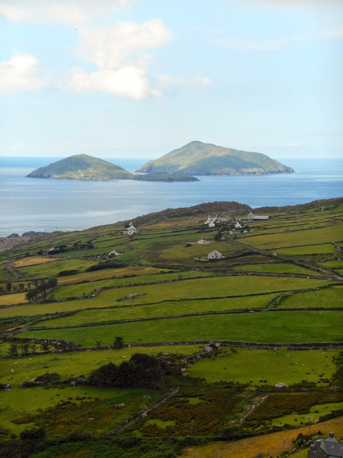
Lots of little island of the coast

Typical hillside farms/ranches - lots of sheep and cattle
The reward for our treacherous yet scenic day of driving was the B&B we had booked for tonight on the top of the west side of the Dingle Peninsula - "Mountain View".  Whereas Friday night's place was "cozy cottage" - this was Southfork (remember Dallas?).  We could have even brought our horse - stables out back.  Just gorgeous, spacious.  I actually found this place because I had first seen a website for an organic/vegetarian restaurant/B&B, but they were full.  Mountain View was nearby, so figured we could do dinner at the organic place.  Glad it worked out the way it did - great for dinner (we even bought their cookbook) - but sort of an odd place. 
This gypsy caravan was in the garden of Phoenix House B&B
We don't think it was for guests - but who knows
But they grow most of their veggies and herbs

After sating our appetites we were able to walk back to our place and settle in for the night.  Tomorrow - the Dingle peninsula (I think more narrow, winding roads) then back to Dublin
The view from our window.